The UK's hardest cities and towns to navigate by car

Travelling around UK roads can often feel like a battle, from standstill queues at rush hour to confusing junctions and gridlocked roundabouts that turn everyday journeys into a test of patience.
As of 2025, the UK is home to 42.5 million licensed drivers, collectively clocking up a staggering 335.9 billion vehicle miles travelled (VMT). Leisure driving is also booming, with 17 million trips recorded over the May bank holiday weekend alone.
With more vehicles on the road than ever, navigating from A to B is becoming increasingly challenging. Whether you're behind the wheel of a brand-new lease car or a reliable used vehicle, one goal unites every motorist - a smooth and stress-free journey.
Therefore, to help drivers plan smarter journeys across the UK, we’ve analysed a range of factors, from estimated yearly traffic and vehicle collisions to the number of roundabouts, traffic signals and navigation-related searches, to uncover the UK’s hardest and easiest towns and cities to navigate by car.
So, which UK cities and towns should you steer clear of, and where can you hit the road without experiencing navigation issues?
- London is the hardest UK city to navigate by car, with 4,840 roundabouts
- The easiest city to navigate is Dundee, with low traffic (539.6 million VMT) and strong internet speed (136)
- Barking and Dagenham is the hardest London borough to navigate, with the highest vehicle collisions (993)
- Gateshead is the most difficult UK town to navigate, with 1.1 billion yearly traffic
- Sunderland is the hardest coastal destination to navigate, with a traffic index score of 137.26
- Cumbernauld, Scotland, has the worst internet speed for drivers, with just 15 Mbps
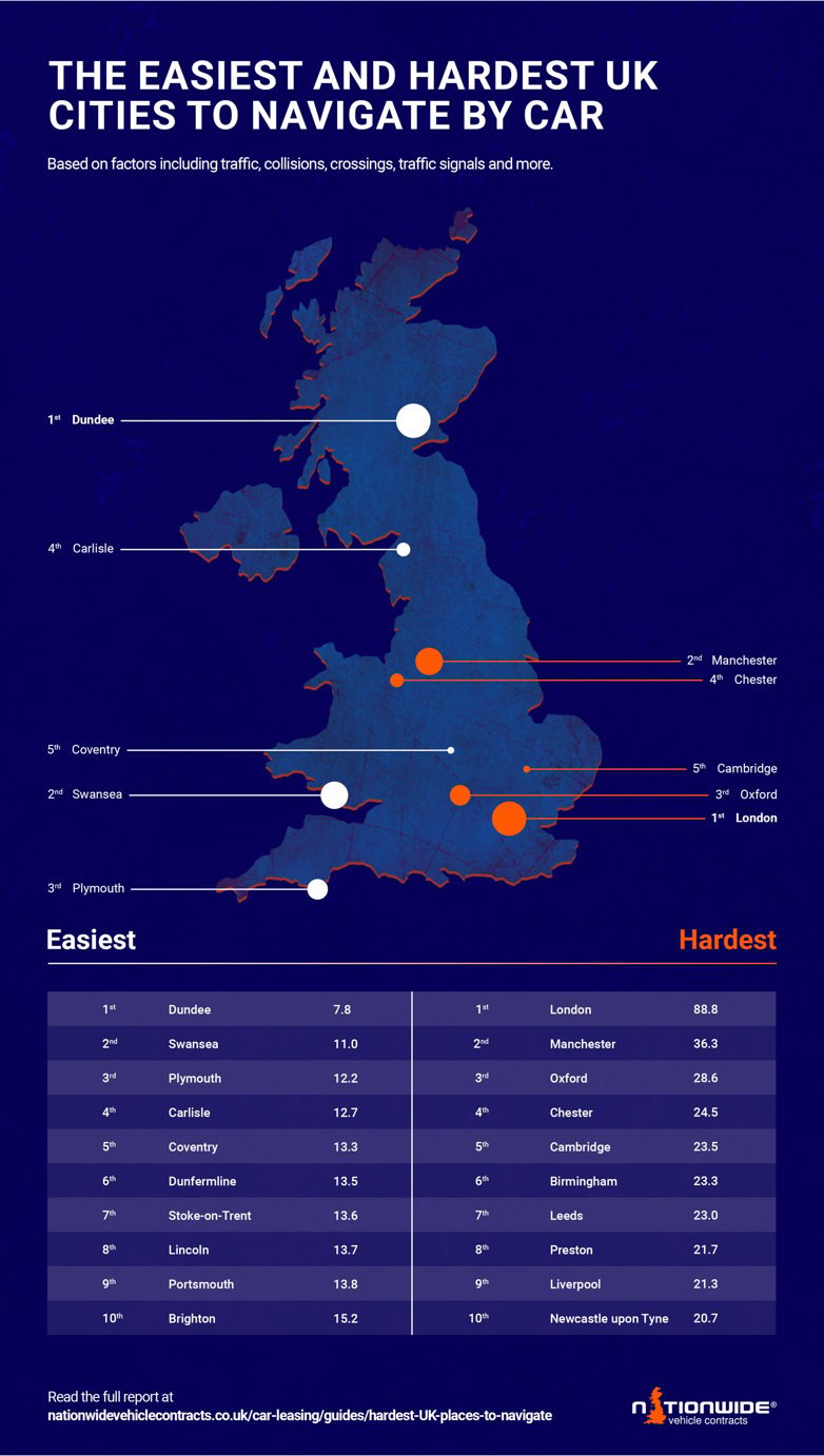
London officially tops the list as the hardest UK city to navigate when driving, as England’s fast-paced capital is home to a staggering 4,840 roundabouts, 15,600 traffic signals (over four times more than Manchester), and 56,000 street crossings. With this level of complexity, getting across the city by car can feel like a real challenge.
Also, with almost 21,000 searches for ‘lost in London’ or ‘trouble navigating London’, it’s clear the city’s chaotic roads are sending drivers and GPS systems into a meltdown.
This bustling Northern powerhouse might have an impressive public transport network with trams, trains and buses, yet for city centre drivers, Manchester is a logistical nightmare as it’s the second hardest UK city to navigate.
Manchester has over 11,200 street crossings, 432 cycle lanes and 1,500 pedestrian-only streets for drivers to look out for, which makes the roads chaotic and tricky to steer. With 463 reported collisions, double the number recorded in Oxford, Manchester roads are complicated for locals and visitors alike.
Oxford claims the third spot for the hardest UK cities to navigate, which is unwelcome news for families and friends visiting students attending the world-famous Oxford University. With over 4.7 billion miles driven by vehicles in this historic city, congestion is guaranteed for drivers.
The rise of Low Traffic Neighbourhoods (LTNs) has created confusion for drivers, and the strict bus-only lanes and ‘bus gates’ can catch out even seasoned local drivers.
If you find yourself lost on one of the 248 pedestrian-only streets crisscrossing Oxford, the city’s 29 Mbps (Megabit per second) may get you to your destination (typically just 0.5-1 Mbps is needed), but it may struggle to support 4G and 5G if those apps require it.

Dundee makes driving feel a breeze as it’s officially the UK’s easiest city to navigate by car, and the most straightforward place to drive in Scotland.
With just 232 roundabouts, 208 traffic signals, and impressively fast Wi-Fi (136 Mbps) to help with navigation, drivers will be able to drive around this dynamic and compact city with ease - making it the perfect location for your next family staycation.
If you’re thinking about a family-friendly road trip to Wales, the city of Swansea has made an appearance as the second easiest city to navigate. There have been just 320 searches for navigation-related queries about Swansea, the lowest out of any city in the UK.
With just 8 cycle lanes and 70 collisions reported in 2023, driving through this city is a stress-free journey - made even more helpful by the fast and reliable internet speed of 107 Mbps!
Plymouth, located on the south coast of Devon, known for its rich maritime history, has also been revealed as one of the best cities for drivers, ranking as the third easiest location to navigate.
With fewer roundabouts than Dundee at just 206 in total, this coastal city is perfect for those who dread going round in circles. Pedestrian-only streets (106) and cycle lanes (13) are few and far between, so drivers won’t have to worry about an overload of one-way streets.
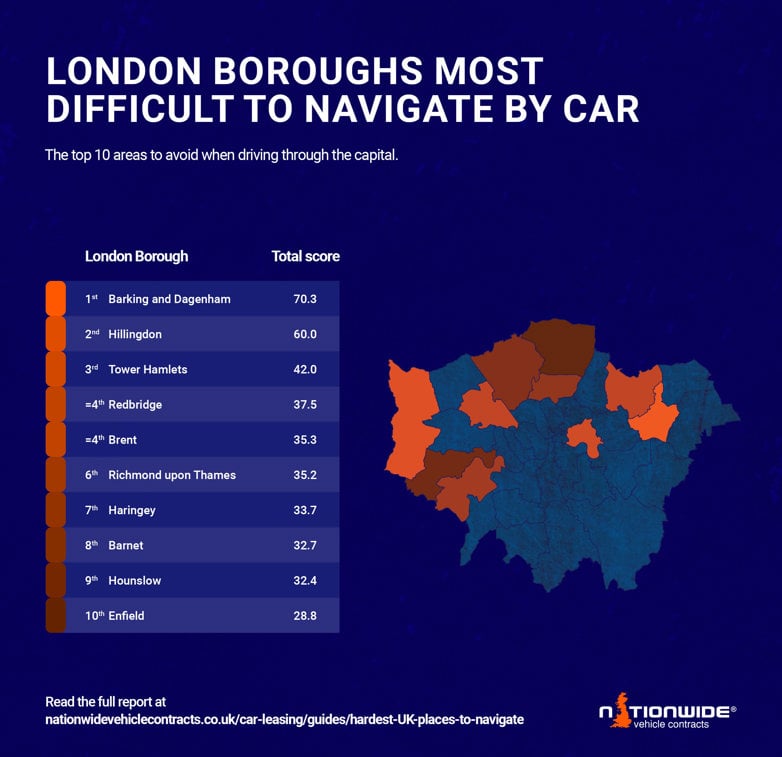
Driving in London is famously tricky, topping the ranking for the hardest city to navigate across the whole of the UK. Therefore, we have analysed which London boroughs are causing the most hassle.
Out of its 33 boroughs, some in particular are known for their poor roads and frequent traffic jams. These are the top three London boroughs that ranked the hardest to navigate:
Barking and Dagenham, in East London, has been crowned the hardest London borough to drive around with a score of 70.3 out of 100.
With a whopping 6,600 searches for being lost in the area, it's no wonder this borough has ranked so high. The area also witnessed 993 collisions in 2023, which is almost double the amount of Hillingdon, with just 542.
The westernmost London borough, Hillingdon, racked up the most vehicle miles out of the top three boroughs, with a total of 1.5 billion vehicle miles travelled (VMT), and it also claims the poorest internet connection at 44 Mbps.
When it comes to confused drivers, Tower Hamlets has 12.1k searches related to being lost in the borough, almost double that of the hardest borough, Barking and Dagenham.
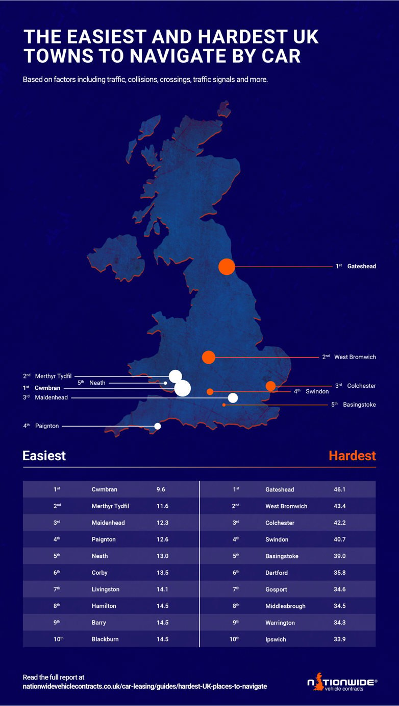
The UK’s cities may be presumably worse with heavy traffic, but some towns across the country are also claiming quite the name for challenging navigation.
Gateshead, just outside Newcastle, has been named the UK’s hardest town to navigate, scoring 46.1 out of 100. Locals battle daily with the never-ending roadworks at Lobley Hill Interchange (A1/A692/A184) and the infamously tricky Testo’s Roundabout on the A19. Despite logging only 1.1 billion VMT, it still saw 337 collisions in 2023.
Following close behind was West Bromwich, where 2,105 street crossings, 288 roundabouts, and 472 collisions make for a testing drive for many visitors.
When it comes to people getting lost, Colchester takes the crown, with 2,400 searches for queries including ‘lost in Colchester’ (five times more than Gateshead) and nearly 10 billion vehicle miles recorded, there are a lot of cars on the road for drivers to navigate.
Cwmbran sits south of the M4 motorway in South Wales, making it well-connected to London. It also houses just 42 roundabouts and 19 traffic signals, making it the easiest town to navigate in the UK.
Despite its less structured layout and hillier terrain, Merthyr Tydfil, just 23 miles North of Cardiff, has been named the second-easiest town to navigate in the UK. It has the lowest VMT in the top 10 towns, with just 28k and has minimal challenges on the roads, such as just 5 cycle paths.
Lastly, it was Maidenhead, with its minimal pedestrian-only streets (8) and healthy traffic index score (138.15), that was named the third-easiest town to navigate, making it the perfect spot for a potter around behind the wheel.
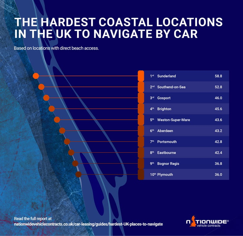
If you’re considering a leisurely trip to explore the UK coastline, these are the locations with direct beach access that will force drivers to bring out their most advanced skills to navigate around:
Despite its beautiful coast and award-winning beaches, Sunderland is riddled with problem roads, from the congested A1231 to the high-speed A19 northbound.
With 898 roundabouts and a traffic index score of 137.26, it’s considered the hardest coastal destination to navigate: scenic, but far from simple.
If you’re craving calm, you might think of heading to Three Shells Beach in Southend-on-Sea, but getting there may not be as peaceful as sitting on the pier.
Southend-on-Sea drivers racked up 4,400 searches about navigation struggles, while Sunderland saw just 1,020. They also saw more collisions in 2023, with 276 compared to 170 collisions in Sunderland.
Then there’s Gosport, with its tranquil Stokes Bay Beach, but that's where the tranquillity ends. The town racked up 9.6 billion vehicle miles travelled (VMT), and is dominated by cycle lanes (61) and pedestrian-only streets (56), indicating quiet roads are a rarity!
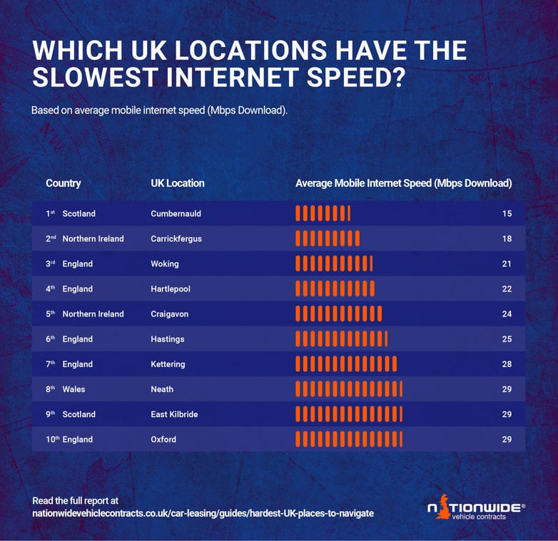
Internet connection may just be the most important thing when on the road, especially when you don't know the route. So if you’re not familiar with Cumbernauld in North Lanarkshire (just less than 14 miles from Glasgow), downloading offline maps is essential as the town has the weakest mobile internet speed at 15 Mbps.
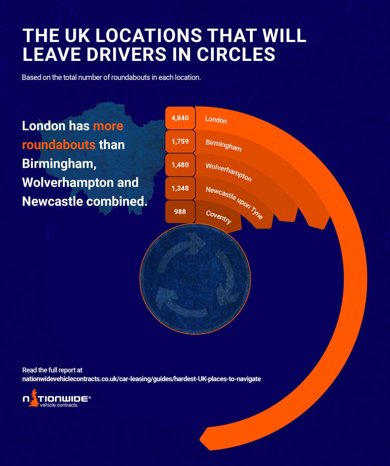
The UK is a land of roundabouts galore, but one city in particular took the ranking by storm, sending residents and visitors around in circles. England’s capital city, London, is home to 4,840 roundabouts — that’s nearly 20 times the number of steps at Covent Garden station.
The West Midlands is a hotspot for roundabouts, with Birmingham having 1,759 in total and nearby Wolverhampton also having a high number of roundabouts at 1,480; however, even when combined, this is still less than London!
To help you plan your next road trip, whether for work or leisure, with a bit more ease, our director, Keith Hawes, has shared his top tips for avoiding tricky navigational issues.
Plan your route - Whether you’re heading across town or taking a longer road trip - plan ahead! Before you set off, take a few minutes to review the journey beforehand so you know potential blockers such as roadworks and major diversions. Understanding this allows you to adapt accordingly and ensure the smoothest journey possible.
Understand UK road signs - There are over 600 different UK road signs, but don’t let that scare you - the majority are simple. The most important are your Regulatory Signs (the ones you MUST follow), such as no entry and speed limits, red triangles (warning signs), information and direct signs, so you don't miss your turns or get caught speeding.
Consider the weather - UK weather is unpredictable, so make sure your vehicle is adequately prepared for a 30º heatwave or sudden rain shower. Always ensure your coolant is full and tyre pressure and tread levels are checked to be ready for any weather changes. Make sure you monitor the weather before driving and pull over if your vision is obstructed.
Download the correct apps - Download a traffic management app so you can be on the lookout for any delays to keep your journey simple and safe.
The UK is home to both challenging and easier-to-navigate cities, but the journey is something you should look forward to by preparing accordingly. By getting behind the wheel of a reliable lease vehicle, the opportunities are endless.
Whether it’s for an hour-long commute or an exciting road trip with a loved one, our wide range of car leasing deals are here to meet every need for whatever your journey brings - no matter how hard (or easy) to navigate!
Nationwide Vehicle Contracts looked at various factors to create a ranking to identify which cities and towns across the UK are the most difficult to navigate by car. We analysed search volumes for Difficulty Navigating Searches, Estimated Yearly Traffic (Vehicle miles travelled (VMT) All Motor Vehicles (Local Authority), Average Mobile Internet Speed (Mbps Download), Congestion Zone/Clean Air Zone/Zero Emission Zone, Traffic Index Numbeo, Vehicle Collisions (2023 latest data), and tags from open street maps for the number of roundabouts, railway crossings, street crossing (pedestrian), traffic signals, pedestrian only streets and cycle lanes in each area. OSM Data is based on what people have tagged and pre-defined areas of coordinates. If there was no data for a certain town or city, the nearest city was taken.
Sources
Number of licensed drivers on UK roads- DVLA
Number of VMT travelled in the UK- UK Department for Transport
Number of trips recorded in May bank holiday 2025- RAC
Search Volumes- Google Trends and Keywordtool.io
Estimated yearly traffic (VMT) - Department for Transport (Local Authority)
Average Mobile Internet Speed (Mbps Download) - SpeedGeo
Congestion Zone/Clean Air Zone/Zero Emission Zone - Eltis
Traffic Index Score - Numbeo
Vehicle Collisions (2023 latest data) - Crash Map and OpenDataNI
Number of roundabouts, railway crossings, street crossings (pedestrian), traffic signals, pedestrian-only streets and cycle lanes in each area- OpenStreetMap
Guide Information
Originally published: 14th August 2025